Buhen Egypt |
The Latest in Computer Techniques
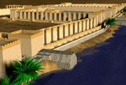
Using the techniques tested on evidence from Giza, Gebel Barkal, Meroe, and Nuri, a 3-dimensional vector model and associated texture maps of the fortifications of Buhen were created (including a simulation of the interior decoration of some spaces and the actual size and type of stone blocks and mudbrick coursing).The individual still images of the Buhen model were generated on an Intel 486-66DX2.
The data was loaded onto a Kubota-Denali computer via a TCP/IP network. The Kubota-Denali was a virtual reality-capable computer that competed with high-end Silicon Graphics computers. Along with the Kubota computer, we utilized Leep's CyberFace 3 (a beam-mounted display used for interactive total immersion) and Sense8's WorldToolKit software to create a real-time VR experience. Subsequently, the Buhen virtual environment data were transposed from the Kubota system to a comparable Evans & Sutherland Freedom 3000 image accelerator with a Sun SPARCstation serving as host, supplied to us by Evans & Sutherland. The world was widely demonstrated throughout 1994.
The Virtual Tour of Buhen
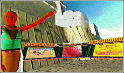
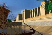
A prepared virtual tour of ancient Buhen began aboard the fully rendered ship of state of the pharaoh docked at quayside. Visitors could experience the scale and beauty of the Egyptian vessel and accompanying cargo ships. Visitors were then led from the ship onto the dock toward and onto the outer fortification walls and 'flown' around the exterior walls (covering several kilometers in just a few moments), then led through the main gate to explore various rooms of the inner city, all the while getting a sense of the immensity of the spaces and the detail of the decorations and building techniques. Virtual visitors were led by a tour guide in the guise of an ancient Egyptian scribe, a computer-generated mannequin who moved through the fortification along a preset path. The virtual visitor always had the ability to look around in all directions, travel along any other pathway, or follow the guide. As the mannequin-scribe-guide moved through the fortress, at predetermined locations, a 3-dimensional reference kiosk was programmed to appear.
The three faces of each kiosk were to contain data corridors providing the inquisitive with additional paths of information or, had the links been fully implemented, portals to other virtual environments, as follows:
- The Left Panel in the Buhen world contained a plan of the fortress indicating where the visitor is standing and in what direction the visitor is looking (including a 'you are here' locator). This panel was to become a fully interactive geographic information system (GIS) database of site-specific and regional geographic, topographic, and locational images and data.
- The Central Panel contained an excavation photograph illustrating the actual conditions of the fortress at the spot at which the visitor is viewing. The image allows the viewer to compare the reconstruction to the archaeological evidence. This panel was to become a fully interactive visual database of all archaeological remains relevant to that particular spot in the virtual ancient environment.
- The Right Panel contained a textual description of subjects of interest in the immediate vicinity. This panel was to represent the viewscreen of an interactive, hypertext database of information about the site or other relevant data about related sites, with the potential capability of allowing the visitor to portal out to a different virtual environment for comparison or further study.
The Big Virtual Picture
We had planned to develop the Buhen world further by linking the reconstruction to reconstructions of the site at different periods of history, so that you, as the virtual traveler, could move between these, traveling in time, seeing history pass before your eyes. Also, as we were experimenting with Buhen, the World Wide Web was just developing, and we worked on ideas for connecting to the expanding number of digital archaeological libraries becoming available on websites.Since the Buhen world was a prototype, many of the planned features were not completed. Learning Sites Inc. virtual worlds now incorporate similar as well as many additional enhancements. The access to supplemental educational and research resources directly through a virtual world, which seemed nearly like science fiction only a decade ago, is now a reality, with promise of still more potential.
Reference
Page Created: December 5, 2004
Page Updated: August 16, 2010
URL:
Page Author: The Institute for the Visualization of History


